Geotools是一个java类库,它提供了很多的标准类和方法来处理空间数据,同时这个类库是构建在OGC标准之上的,是OGC思想的一种实现。
而OGC是国际标准,所以geotools将来必定会成为开源空间数据处理的主要工具,目前的大部分开源软件,如udig,geoserver等,
对空间数据的处理都是由geotools来做支撑。而其他很多的web服务,命令行工具和桌面程序都可以由geotools来实现。
geotools官方网站:
其官网有快速开始的指南。

注:
博客:
https://blog.csdn.net/badao_liumang_qizhi
关注公众号
霸道的程序猿
获取编程相关电子书、教程推送与免费下载。
点击Quickstart,然后选择Intellij Quickstart

然后就可以按照其官方指南快速开始。
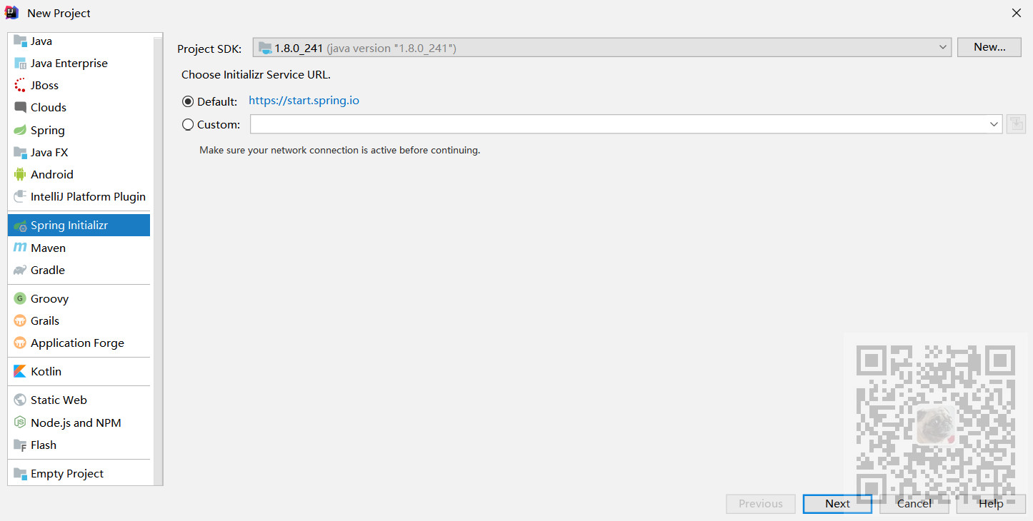
这里新建项目的方式,没有使用官方文档中的Maven的quick start。而是选择新建项目时选择SpingInitializr快速新建项目
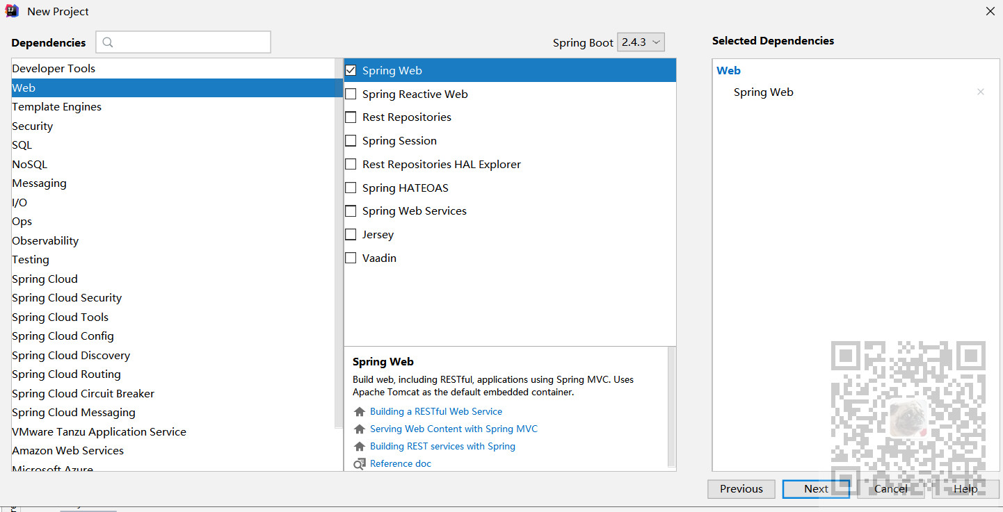
然后添加最基本的web依赖
然后打开新建项目后的pom.xml
首先添加geotools的版本属性
    <properties>
        <java.version>1.8</java.version>
        <project.build.sourceEncoding>UTF-8</project.build.sourceEncoding>
        <geotools.version>26-SNAPSHOT</geotools.version>
    </properties>
这里使用的版本是26
然后在denpendencies中添加geotools相关的依赖
        <dependency>
            <groupId>junit</groupId>
            <artifactId>junit</artifactId>
            <version>4.13.1</version>
            <scope>test</scope>
        </dependency>
        <dependency>
            <groupId>org.geotools</groupId>
            <artifactId>gt-shapefile</artifactId>
            <version>${geotools.version}</version>
        </dependency>
        <dependency>
            <groupId>org.geotools</groupId>
            <artifactId>gt-swing</artifactId>
            <version>${geotools.version}</version>
        </dependency>
添加完依赖之后,此时Maven会提示无法下载依赖,需要再添加repository,以供Maven去下载相关依赖
    <repositories>
        <repository>
            <id>osgeo</id>
            <name>OSGeo Release Repository</name>
            <url>https://repo.osgeo.org/repository/release/</url>
            <snapshots><enabled>false</enabled></snapshots>
            <releases><enabled>true</enabled></releases>
        </repository>
        <repository>
            <id>osgeo-snapshot</id>
            <name>OSGeo Snapshot Repository</name>
            <url>https://repo.osgeo.org/repository/snapshot/</url>
            <snapshots><enabled>true</enabled></snapshots>
            <releases><enabled>false</enabled></releases>
        </repository>
    </repositories>
完整的pom文件代码
<?xml version="1.0" encoding="UTF-8"?>
<project xmlns="http://maven.apache.org/POM/4.0.0" xmlns:xsi="http://www.w3.org/2001/XMLSchema-instance"
         xsi:schemaLocation="http://maven.apache.org/POM/4.0.0 https://maven.apache.org/xsd/maven-4.0.0.xsd">
    <modelVersion>4.0.0</modelVersion>
    <parent>
        <groupId>org.springframework.boot</groupId>
        <artifactId>spring-boot-starter-parent</artifactId>
        <version>2.4.3</version>
        <relativePath/> <!-- lookup parent from repository -->
    </parent>
    <groupId>com.badao</groupId>
    <artifactId>geotoolsdemo</artifactId>
    <version>0.0.1-SNAPSHOT</version>
    <name>geotoolsdemo</name>
    <description>Demo project for Spring Boot</description>
    <properties>
        <java.version>1.8</java.version>
        <project.build.sourceEncoding>UTF-8</project.build.sourceEncoding>
        <geotools.version>26-SNAPSHOT</geotools.version>
    </properties>
    <repositories>
        <repository>
            <id>osgeo</id>
            <name>OSGeo Release Repository</name>
            <url>https://repo.osgeo.org/repository/release/</url>
            <snapshots><enabled>false</enabled></snapshots>
            <releases><enabled>true</enabled></releases>
        </repository>
        <repository>
            <id>osgeo-snapshot</id>
            <name>OSGeo Snapshot Repository</name>
            <url>https://repo.osgeo.org/repository/snapshot/</url>
            <snapshots><enabled>true</enabled></snapshots>
            <releases><enabled>false</enabled></releases>
        </repository>
    </repositories>
    <dependencies>
        <dependency>
            <groupId>org.springframework.boot</groupId>
            <artifactId>spring-boot-starter-web</artifactId>
        </dependency>

        <dependency>
            <groupId>org.springframework.boot</groupId>
            <artifactId>spring-boot-starter-test</artifactId>
            <scope>test</scope>
        </dependency>
        <dependency>
            <groupId>junit</groupId>
            <artifactId>junit</artifactId>
            <version>4.13.1</version>
            <scope>test</scope>
        </dependency>
        <dependency>
            <groupId>org.geotools</groupId>
            <artifactId>gt-shapefile</artifactId>
            <version>${geotools.version}</version>
        </dependency>
        <dependency>
            <groupId>org.geotools</groupId>
            <artifactId>gt-swing</artifactId>
            <version>${geotools.version}</version>
        </dependency>
    </dependencies>

    <build>
        <plugins>
            <plugin>
                <groupId>org.springframework.boot</groupId>
                <artifactId>spring-boot-maven-plugin</artifactId>
            </plugin>
        </plugins>
    </build>

</project>
然后就是等待Maven去下载相关依赖
下载完成后就可以在项目依赖中看到

然后在包下新建一个java类叫quickstart
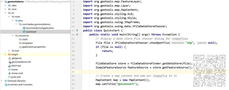
此类的示例代码为
package com.badao.geotoolsdemo;
import java.io.File;
import org.geotools.data.FileDataStore;
import org.geotools.data.FileDataStoreFinder;
import org.geotools.data.simple.SimpleFeatureSource;
import org.geotools.map.FeatureLayer;
import org.geotools.map.Layer;
import org.geotools.map.MapContent;
import org.geotools.styling.SLD;
import org.geotools.styling.Style;
import org.geotools.swing.JMapFrame;
import org.geotools.swing.data.JFileDataStoreChooser;
public class Quickstart {
    public static void main(String[] args) throws Exception {
        // display a data store file chooser dialog for shapefiles
        File file = JFileDataStoreChooser.showOpenFile("shp", null);
        if (file == null) {
            return;
        }

        FileDataStore store = FileDataStoreFinder.getDataStore(file);
        SimpleFeatureSource featureSource = store.getFeatureSource();

        // Create a map content and add our shapefile to it
        MapContent map = new MapContent();
        map.setTitle("Quickstart");

        Style style = SLD.createSimpleStyle(featureSource.getSchema());
        Layer layer = new FeatureLayer(featureSource, style);
        map.addLayer(layer);

        // Now display the map
        JMapFrame.showMap(map);
    }
}
然后运行此类的main方法
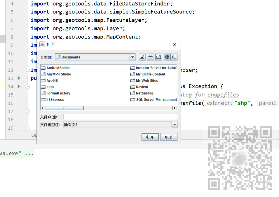
会弹出选择shp文件的选择框
Shapefile属于一种矢量图形格式,它能够保存几何图形的位置及相关属性。但这种格式没法存储地理数据的拓扑信息。
其中,要组成一个Shapefile,有三个文件是必不可少的,它们分别是".shp", ".shx"与 ".dbf"文件
.shp— 图形格式,用于保存元素的几何实体。
.shx—
图形索引格式。几何体位置索引,记录每一个几何体在shp文件之中的位置,能够加快向前或向后搜索一个几何体的效率。
.dbf— 属性数据格式,以dBase IV的数据表格式存储每个几何形状的属性数据。
首先你要有一个shp文件,这里提供一个中国省级行政区划_shp地图数据文件:
https://download.csdn.net/download/BADAO_LIUMANG_QIZHI/15785012
注意选择的shp文件不要有中文名和中文路径
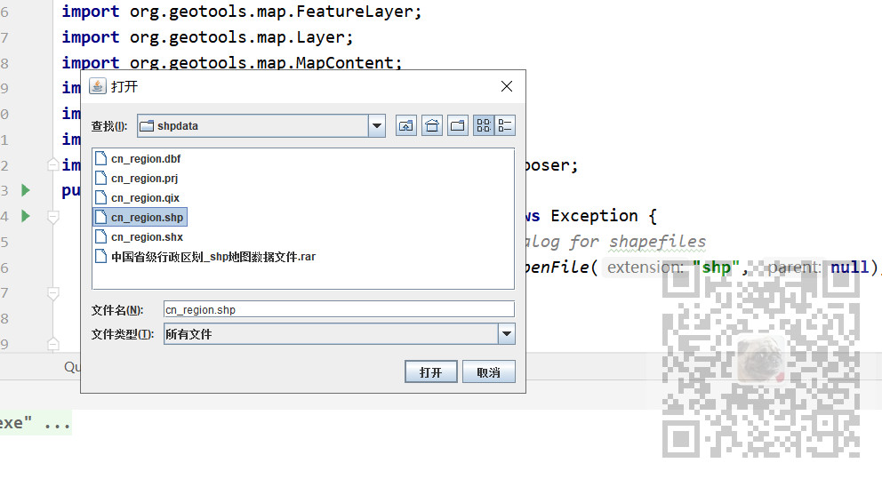
然后点击打开
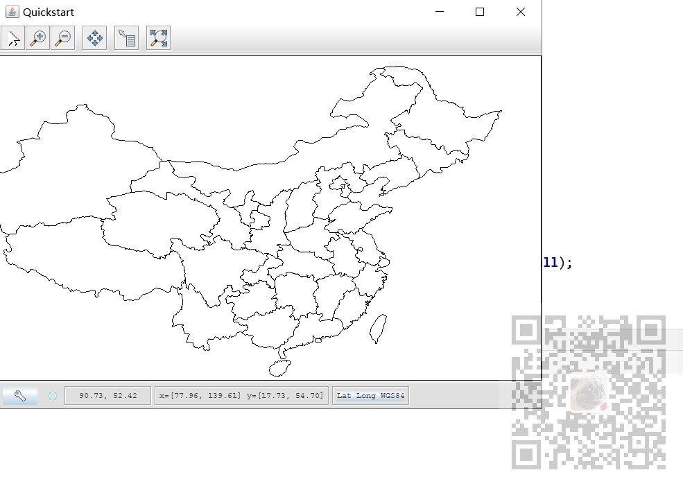
Geotoos简介以及quickstsrt加载shp文件并显示
原文:https://www.cnblogs.com/badaoliumangqizhi/p/14543212.html